主管:中国科学院
主办:中国优选法统筹法与经济数学研究会
中国科学院科技战略咨询研究院
主办:中国优选法统筹法与经济数学研究会
中国科学院科技战略咨询研究院
中国管理科学 ›› 2025, Vol. 33 ›› Issue (7): 187-199.doi: 10.16381/j.cnki.issn1003-207x.2023.1011
• • 上一篇
郑秋爽, 王长峰( )
)
收稿日期:2023-06-14
修回日期:2023-11-06
出版日期:2025-07-25
发布日期:2025-08-06
通讯作者:
王长峰
E-mail:wangcf@bupt.edu.cn
基金资助:
Qiushuang Zheng, Changfeng Wang()
Received:2023-06-14
Revised:2023-11-06
Online:2025-07-25
Published:2025-08-06
Contact:
Changfeng Wang
E-mail:wangcf@bupt.edu.cn
摘要:
随着煤层向深度延伸,地质条件趋于更加复杂,导致灾变突水更加难以探查,造成重大人员伤亡和财产损失。本文基于钻孔地质数据小样本非线性的特征,提出了耦合理论分析、统计学分析,数值模拟和机器学习仿真的多元集成分析风险预测定量模型。首先,使用三角模糊数定量化表征基于经验值的对比矩阵,同时考虑底层主控风险因子的网络化风险传递作用,并采用博弈矩阵对主控因素的主客观权重占比合理分配,构建基于主客观双因子综合赋权的富水性指数模型。其次,采用PSO-SVM-GIS模型充分挖掘导水通道数据联系,利用协同克里金插值实现数据的升维和空间信息处理。最后,通过风险的充要条件图层表征耦合,实现定量结果的定性可视化,达到以小样本数据精准预测灾害风险的目的。结果表明:基于多元集成分析的三图法优化模型具有较高的精度和泛化能力,真实刻画了矿井突水这种受控于多因素、数据体量小、且具有非常复杂形成机理的非线性动力过程,实现了对于突水高风险区的精准研判,可为制定针对性防治水措施提供技术支撑,从而前瞻性确保了煤矿安全生产。
中图分类号:
郑秋爽, 王长峰. 基于多元集成分析的矿井突水风险预测优化模型及算法研究[J]. 中国管理科学, 2025, 33(7): 187-199.
Qiushuang Zheng, Changfeng Wang. Prediction of Roof Water Inrush Based on Multivariate Integrated Analysis Model[J]. Chinese Journal of Management Science, 2025, 33(7): 187-199.
图1
模型流程"

表1
模型符号与定义"
| 符号 | 定义 |
|---|---|
| c | 导水裂缝带支持向量机回归预测模型惩罚系数 |
| g | 导水裂缝带支持向量机回归预测模型核参数 |
| Y={Yij }m×n | 富水性主控因子原始数据m×n标准矩阵 |
| Ej | 第j项主控因子的信息熵 |
| Dj | 第j项主控因子的差异性系数 |
| Wj | 第j项主控因子的权重 |
| ak | 线性组合系数 |
| w | 熵权或网络层次分析法求得的权重向量 |
| Si | 权重和模糊综合程度 |
| 加权超矩阵 | |
| 极限超矩阵 | |
| V(M1≥M2) | 三角模糊数M1≥M2的可能性程度 |
| CI | 富水性指数 |
| Wk | 富水性主客观双因子赋权 |
| n | 富水性单因素数量 |
| fk | 富水性单因素影响值函数 |

图2
PSO-SVM模型"
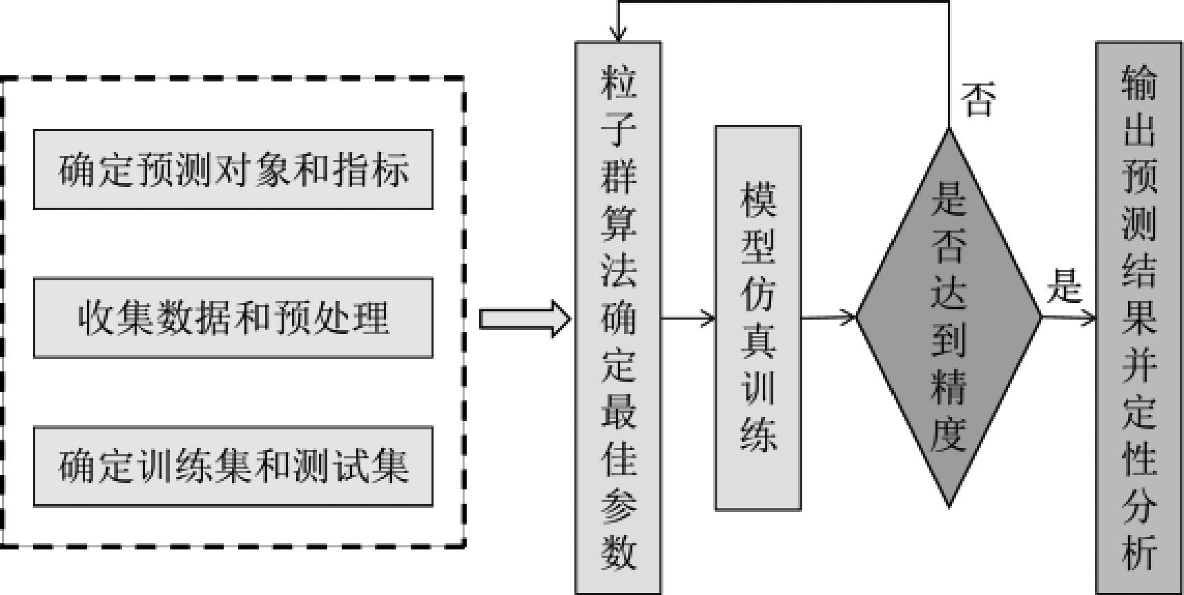
图3
ANP递阶层次结构"

图4
计算流程图"

表2
西部矿区两带高度数据统计"
| 序号 | 矿名 | 工作面 | 面长/米 | 采高/米 | 裂缝带高度/米 | 裂采比(%) |
|---|---|---|---|---|---|---|
| 1 | 大柳塔煤矿 | 52304 | 147.5 | 6.44 | 68.76 | 10.7 |
| 2 | 大柳塔煤矿 | 52306 | 301 | 7 | 137.32 | 19.6 |
| 3 | 国投查哈素煤矿 | 3103顺槽 | 300 | 5.1 | 63.1 | 12.4 |
| 4 | 补连塔煤矿 | 12511 | 319.1 | 8 | 124.42 | 15.6 |
| 5 | 补连塔煤矿 | 31401 | 265 | 5.92 | 147.2 | 24.9 |
| 6 | 泰安煤矿 | 6103 | 195 | 6 | 63.4 | 10.6 |
| 7 | 上湾煤矿 | 51201 | 155 | 5.8 | 73 | 12.6 |
| 8 | 布尔台煤矿 | 42106 | 216 | 6.6 | 80.52 | 12.2 |
| 9 | 张家峁煤矿 | 15204 | 300 | 6 | 75.6 | 12.6 |
| 10 | 陈家沟煤矿 | 3202 | 98 | 10.79 | 134.98 | 12.5 |
| 11 | 多伦协鑫煤矿 | 1703-1 | 120 | 9.58 | 112 | 11.7 |
| 12 | 金鸡滩煤矿 | 101 | 300 | 5.5 | 108.59 | 19.7 |
| 13 | 杭来湾港煤矿 | 30101 | 300 | 7.5 | 112.6 | 15 |
| 14 | 彬长煤矿 | 101 | 116 | 7.4 | 96.4 | 13 |
| 15 | 王坡煤矿 | 3202 | 180 | 5.89 | 104.92 | 17.8 |
| 16 | 敏东一矿 | L3414 | 196 | 7.7 | 79.78 | 10.4 |
图5
粒子群算法参数寻优"
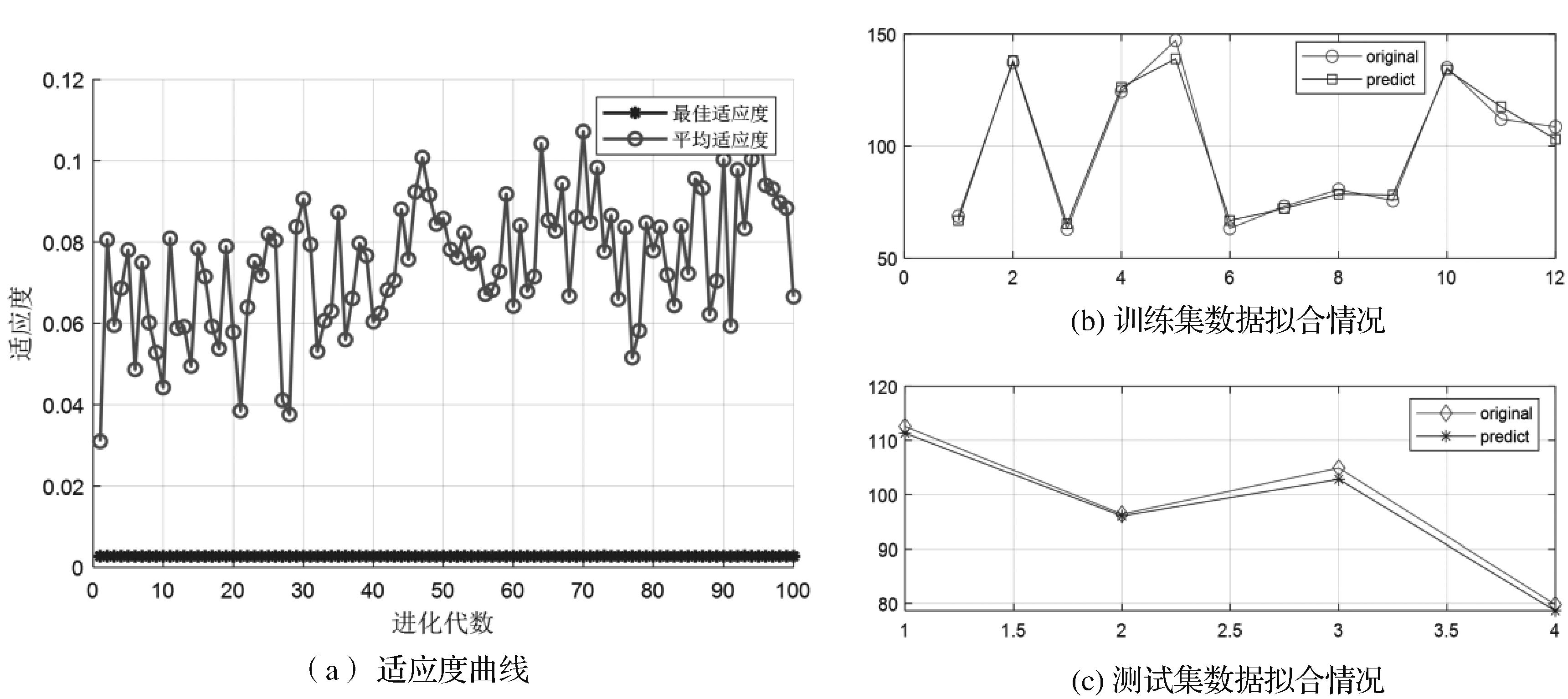
图6
网格算法参数寻优"

图7
遗传算法参数寻优"
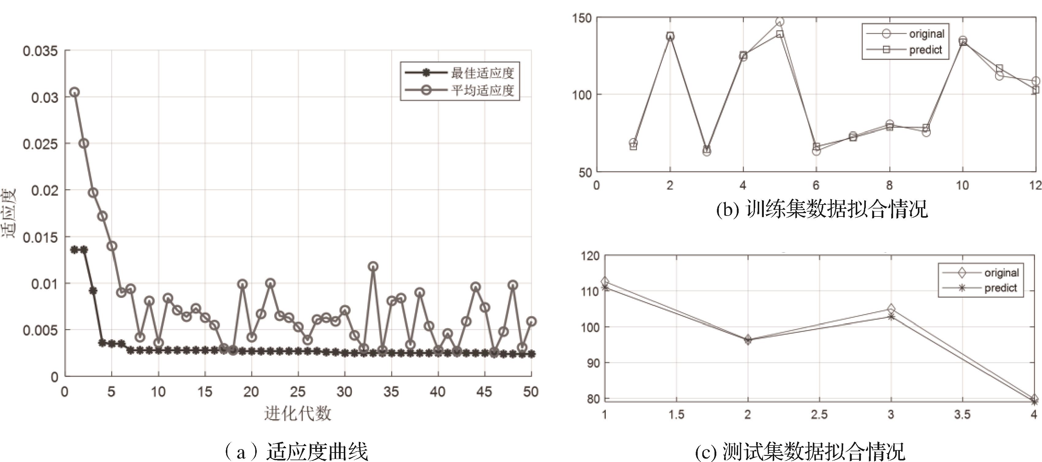
图8
遗传算法cgp参数寻优"

表3
寻优预测方案精度对比"
| 寻优算法 | c | g | MAE(%) | MSE(%) |
|---|---|---|---|---|
| PSO-cg | 29.2697 | 0.1 | 9.51 | 14.66 |
| 网格-cg | 9.1896 | 0.027205 | 16.73 | 19.32 |
| 遗传-cg | 5.0331 | 0.031567 | 40.16 | 61.59 |
| 遗传-cgp | 14.9429 | 1.4256 | 17.26 | 23.85 |
表4
PSO-SVM模型导水裂缝带预测值"
| 测试点标号 | 采高/米 | 导水裂缝带高度/米 |
|---|---|---|
| ST-01 | 5.51 | 78.47 |
| ST-02 | 2.32 | 28.51 |
| ST-03 | 5.89 | 65.06 |
| ST-04 | 4.12 | 49.14 |
| ST-05 | 6.11 | 74.18 |
| ST-06 | 5.92 | 67.09 |
| ST-07 | 5.57 | 61.43 |
| ST-08 | 6.72 | 82.95 |
| ST-09 | 4.98 | 55.72 |
| ST-10 | 6.02 | 69.08 |
| ST-11 | 6.43 | 79.11 |
| ST-12 | 4.68 | 52.03 |
| ST-13 | 6.24 | 75.94 |
| ST-14 | 6.72 | 65.32 |
| ST-15 | 6.01 | 67.43 |
| ST-16 | 6.42 | 78.05 |
| ST-17 | 5.86 | 63.98 |

图9
营盘壕矿导水裂缝带发育高度分布"
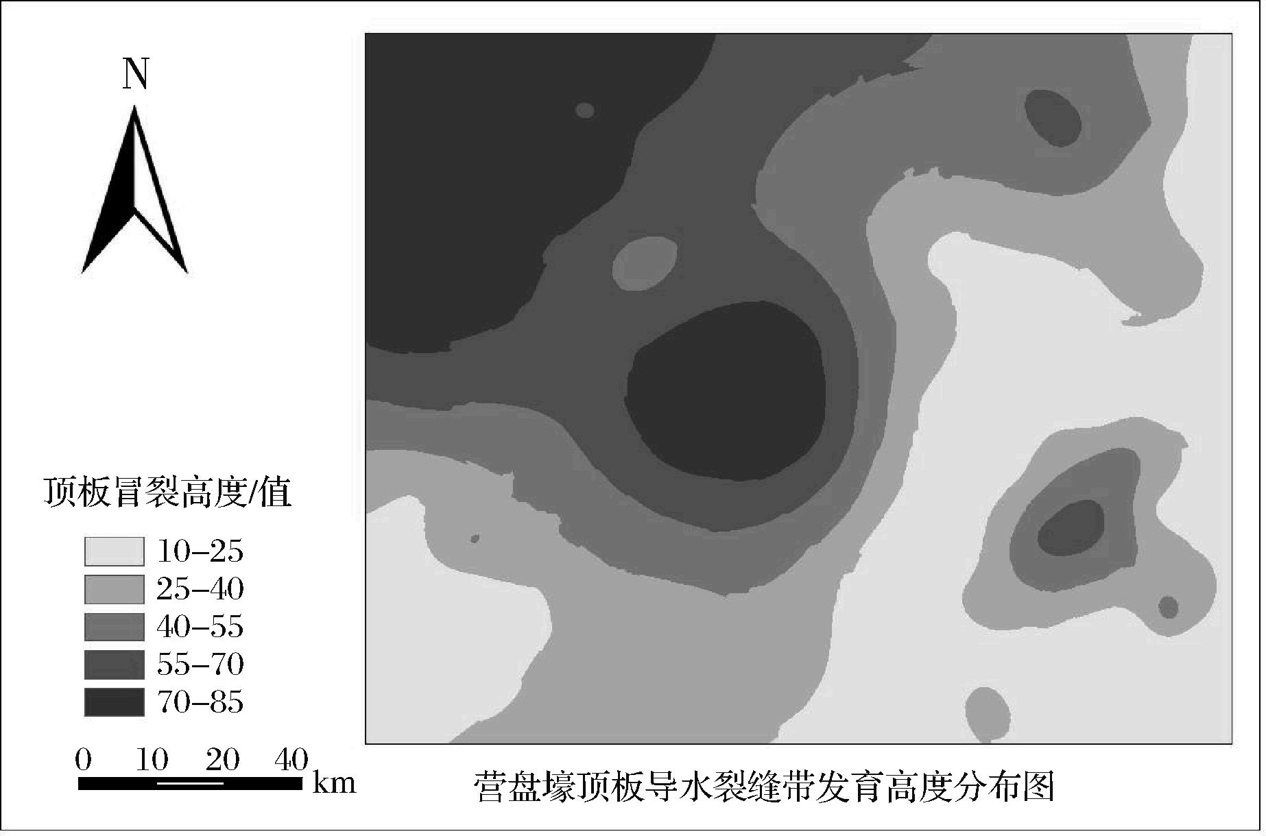
表5
直接充水含水层主控因素原始数据统计"
| 钻孔 | 含水层厚度/米 | 隔水层厚度/米 | 岩芯采取率/% | 渗透系数/(dm/d) | 砂岩岩性系数 |
|---|---|---|---|---|---|
| K4-1 | 214.81 | 621.65 | 0.94 | 0.34 | 0.22 |
| K4-2 | 178.65 | 529.08 | 0.88 | 0.41 | 0.40 |
| K4-3 | 179.78 | 603.45 | 0.94 | 0.28 | 0.23 |
| K4-4 | 170.70 | 622.80 | 0.86 | 0.28 | 0.21 |
| K4-5 | 168.43 | 509.52 | 0.84 | 0.32 | 0.24 |
| K4-6 | 150.96 | 567.04 | 0.79 | 0.33 | 0.28 |
| K4-7 | 148.46 | 644.17 | 0.81 | 0.37 | 0.27 |
| K4-8 | 149.59 | 603.55 | 0.82 | 0.41 | 0.40 |
| K4-9 | 148.46 | 578.39 | 0.85 | 0.33 | 0.22 |
| K4-10 | 135.52 | 524.08 | 0.79 | 0.36 | 0.26 |
| K5-1 | 178.21 | 675.28 | 0.79 | 0.49 | 0.45 |
| K5-2 | 177.29 | 623.05 | 0.68 | 0.08 | 0.13 |
| K5-3 | 165.71 | 568.91 | 0.66 | 0.36 | 0.27 |
| K5-4 | 161.40 | 584.38 | 0.73 | 0.12 | 0.17 |
| K5-5 | 163.89 | 519.63 | 0.92 | 0.55 | 0.50 |
| K5-6 | 146.19 | 697.02 | 0.79 | 0.45 | 0.33 |
| K5-7 | 142.33 | 673.47 | 0.79 | 0.14 | 0.19 |
| K5-8 | 140.51 | 605.40 | 0.76 | 0.59 | 0.46 |
| K6-1 | 173.20 | 549.84 | 0.74 | 0.28 | 0.31 |
| K6-2 | 154.13 | 503.90 | 0.89 | 0.35 | 0.29 |
| K6-3 | 134.38 | 614.07 | 0.69 | 0.50 | 0.46 |
| K6-4 | 135.75 | 619.80 | 0.88 | 0.40 | 0.39 |
| K7-1 | 169.80 | 582.25 | 0.91 | 0.34 | 0.29 |
| K7-2 | 156.86 | 694.03 | 0.89 | 0.40 | 0.38 |
| K7-3 | 197.77 | 588.09 | 0.90 | 0.36 | 0.25 |
| K7-4 | 158.45 | 634.75 | 0.91 | 0.57 | 0.46 |
| K7-5 | 140.97 | 660.21 | 0.90 | 0.28 | 0.35 |
| K7-6 | 149.82 | 546.50 | 0.92 | 0.53 | 0.49 |
| K7-7 | 144.83 | 573.46 | 0.94 | 0.41 | 0.32 |
| K7-8 | 133.02 | 628.20 | 0.92 | 0.27 | 0.35 |
| K8-1 | 165.26 | 510.66 | 0.97 | 0.07 | 0.15 |
| K8-2 | 157.31 | 584.31 | 0.87 | 0.25 | 0.39 |
| K8-3 | 139.15 | 605.30 | 0.81 | 0.24 | 0.21 |
| K8-4 | 185.75 | 617.62 | 0.64 | 0.54 | 0.56 |
| P7 | 140.51 | 540.59 | 0.76 | 0.24 | 0.25 |
| P8 | 182.28 | 600.50 | 0.75 | 0.44 | 0.39 |
| P9 | 178.88 | 554.98 | 0.81 | 0.33 | 0.33 |
| P10 | 158.90 | 627.24 | 0.75 | 0.58 | 0.58 |
| X202 | 161.17 | 615.02 | 0.76 | 0.31 | 0.25 |
| X203 | 213.12 | 591.32 | 0.76 | 0.45 | 0.33 |
| X204 | 162.31 | 663.40 | 0.79 | 0.28 | 0.18 |
图10
富水性主控因素归一化专题图"
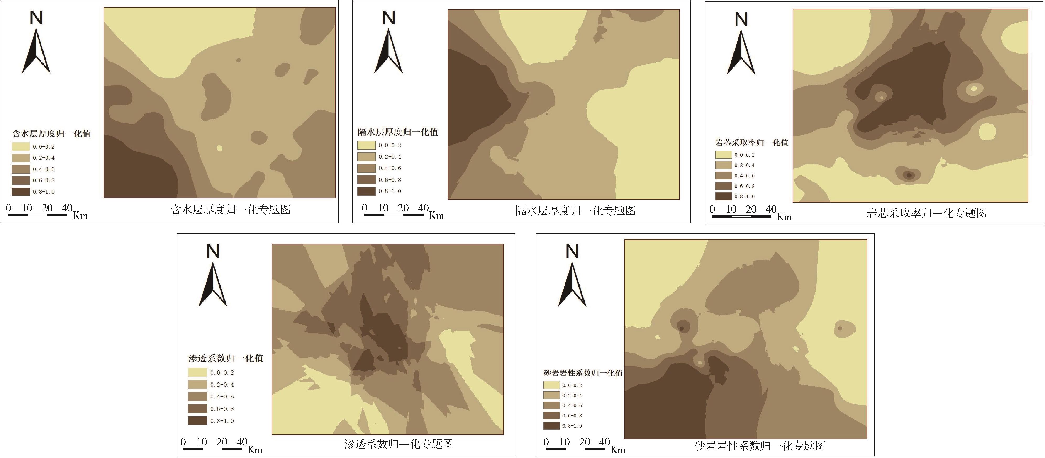
表6
主控因素熵权法计算结果"
评价 指标 | 含水层 厚度 | 隔水层 厚度 | 岩芯采 取率 | 渗透 系数 | 砂岩岩性系数 |
|---|---|---|---|---|---|
| 熵值 | 0.0185 | 0.0146 | 0.0214 | 0.0031 | 0.0163 |
| 权重 | 0.253 | 0.194 | 0.284 | 0.053 | 0.216 |
图11
顶板富水性主控因素ANP结构模型"
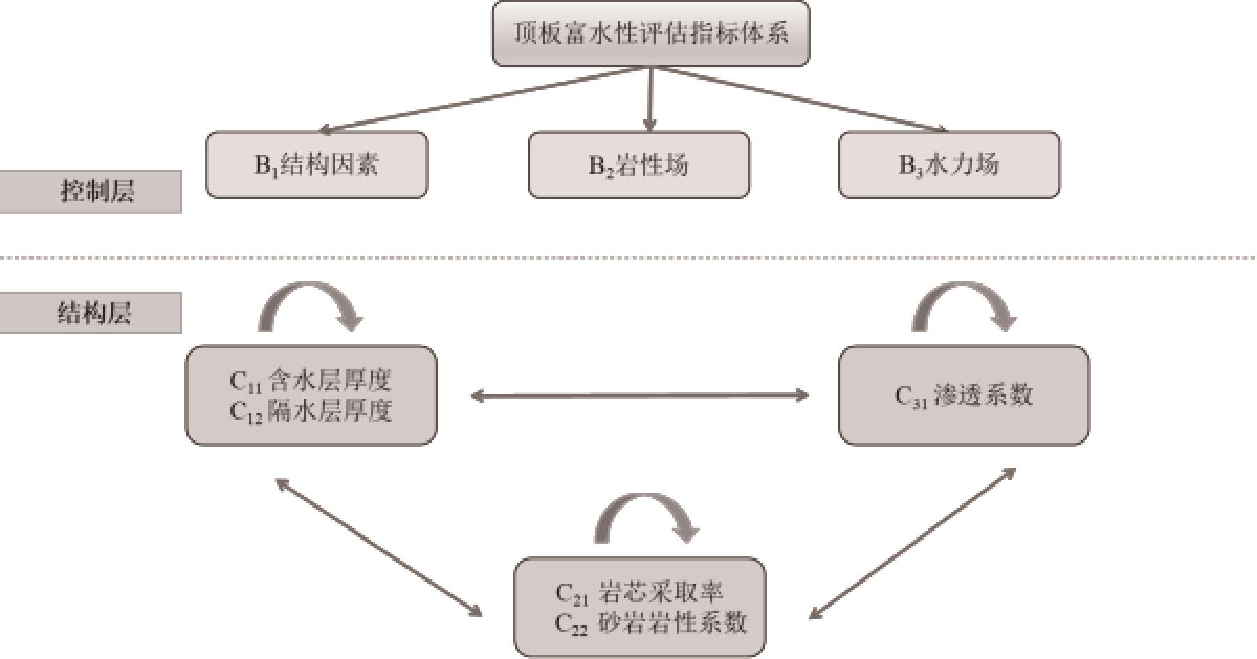
表7
结构因素基本面比较矩阵"
| 富水性主控因素基本面 | B1 | B2 | B3 |
|---|---|---|---|
| B1 | (1,1,1) | (3,4,5) | (2,3,4) |
| B2 | (1/5,1/4,1/3) | (1,1,1) | (1/3,1/2,1) |
| B3 | (1/4,1/3,1/2) | (1,2,3) | (1,1,1) |
表8
未赋权超矩阵"
| 系数 | C11 | C12 | C21 | C22 | C31 |
|---|---|---|---|---|---|
| C11 | 0.000 | 0.000 | 0.750 | 0.167 | 0.333 |
| C12 | 0.000 | 0.000 | 0.250 | 0.833 | 0.667 |
| C21 | 0.800 | 0.111 | 0.000 | 0.000 | 0.500 |
| C22 | 0.200 | 0.889 | 0.000 | 0.000 | 0.500 |
| C31 | 1.000 | 1.000 | 1.000 | 1.000 | 0.000 |
表9
赋权超矩阵"
| 系数 | C11 | C12 | C21 | C22 | C31 |
|---|---|---|---|---|---|
| C11 | 0.000 | 0.000 | 0.600 | 0.133 | 0.037 |
| C12 | 0.000 | 0.000 | 0.200 | 0.667 | 0.074 |
| C21 | 0.711 | 0.099 | 0.000 | 0.000 | 0.444 |
| C22 | 0.178 | 0.790 | 0.000 | 0.000 | 0.444 |
| C31 | 0.111 | 0.111 | 0.200 | 0.200 | 0.000 |
表10
主控因素模糊网络层次分析法计算结果"
评价 指标 | 含水层 厚度 | 隔水层 厚度 | 岩芯采 取率 | 渗透 系数 | 砂岩岩性 系数 |
|---|---|---|---|---|---|
| 权重 | 0.160 | 0.232 | 0.198 | 0.273 | 0.137 |
表11
综合权重值"
评价 指标 | 含水层 厚度 | 隔水层 厚度 | 岩芯采 取率 | 渗透 系数 | 砂岩岩性 系数 |
|---|---|---|---|---|---|
| 权重 | 0.217 | 0.209 | 0.251 | 0.137 | 0.186 |
图12
脆弱性指数阈值划分"
表12
脆弱性指数阈值划分"
| 脆弱性指数阈值 | 评价分区 |
|---|---|
| 弱富水区 | |
| 较弱富水区 | |
| 过渡区 | |
| 较强富水区 | |
| 强富水区 |

图13
营盘壕煤层顶板富水性分区"
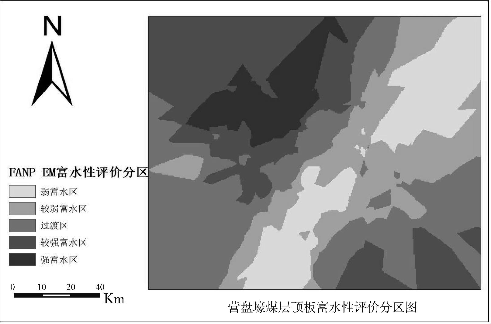
图14
营盘壕矿顶板突水危险性分区"
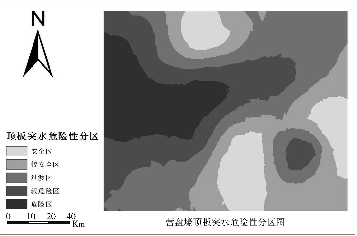
表13
顶板突水危险性预测结果"
| 钻孔 | 冒裂程度高低 | 富水性强弱 | 顶板突水危险性测度 |
|---|---|---|---|
| K4-1 | 2 | 1 | 较安全区 |
| K4-2 | 2 | 3 | 危险区 |
| K4-3 | 2 | 2 | 较危险区 |
| K4-4 | 2 | 1 | 较安全区 |
| K4-5 | 2 | 1 | 较安全区 |
| K4-6 | 2 | 1 | 较安全区 |
| K4-7 | 2 | 1 | 较安全区 |
| K4-8 | 2 | 1 | 较安全区 |
| K4-9 | 2 | 1 | 较安全区 |
| K4-10 | 2 | 2 | 较安全区 |
| K5-1 | 2 | 3 | 危险区 |
| K5-2 | 2 | 2 | 较危险区 |
| K5-3 | 2 | 2 | 较危险区 |
| K5-4 | 2 | 1 | 过渡区 |
| K5-5 | 2 | 2 | 较危险区 |
| K5-6 | 2 | 2 | 较危险区 |
| K5-7 | 1 | 2 | 安全区 |
| K5-8 | 1 | 2 | 安全区 |
| K6-1 | 2 | 2 | 过渡区 |
| K6-2 | 2 | 2 | 过渡区 |
| K6-3 | 1 | 1 | 安全区 |
| K6-4 | 1 | 1 | 安全区 |
| K7-1 | 2 | 2 | 安全区 |
| K7-2 | 2 | 2 | 过渡区 |
| K7-3 | 2 | 1 | 较危险区 |
| K7-4 | 2 | 1 | 较危险区 |
| K7-5 | 1 | 1 | 较危险区 |
| K7-6 | 2 | 2 | 过渡区 |
| K7-7 | 2 | 3 | 过渡区 |
| K7-8 | 1 | 2 | 安全区 |
| K8-1 | 2 | 1 | 安全区 |
| K8-2 | 2 | 2 | 安全区 |
| K8-3 | 1 | 1 | 安全区 |
| K8-4 | 3 | 3 | 危险区 |
| P7 | 2 | 2 | 较危险区 |
| P8 | 3 | 3 | 危险区 |
| P9 | 2 | 2 | 较危险区 |
| P10 | 2 | 2 | 较危险区 |
| X202 | 2 | 2 | 危险区 |
| X203 | 2 | 2 | 过渡区 |
| X204 | 1 | 1 | 过渡区 |
| [1] | 江深哲,杜浩锋,徐铭梽.“双碳”目标下能源与产业双重结构转型[J].数量经济技术经济研究,2024,41(2):109-130. |
| Jiang S Z, Du H F, Xu M Z. Dual transition of energy and industrial structure under the carbon peaking and neutrality goals[J]. Journal of Quantitative & Technological Economics, 2024, 41(2):109-130. | |
| [2] | 陈伟光,罗艾桦,程远州.积极转型,推动能源结构趋绿[N].人民日报, 2023-01-19(10). |
| Chen W G, Luo A H, Cheng Y Z. Positive transformation to promote a greening of the energy structure[N]. People's Daily, 2023-01-19(10). | |
| [3] | 卫思谕.加快构建我国新型能源体系[N].中国社会科学报, 2023-03-06(2). |
| Wei S Y. Accelerating the construction of China's new energy system[N]. Social Sciences in China Press, 2023-03-06(2). | |
| [4] | 曾一凡,武强,赵苏启,等.我国煤矿水害事故特征、致因与防治对策[J].煤炭科学技术,2023,51(7):1-14. |
| Zeng Y F, Wu Q, Zhao S Q, et al. Characteristics, causes, and prevention measures of coal mine water hazard accidents in China[J]. Coal Science and Technology, 2023,51(7):1-14. | |
| [5] | 翟晓荣,吴基文,张红梅 等.基于流固耦合的深部煤层采动底板突水机理研究[J].煤炭科学技术,2017,45(6):170-175. |
| Zhai X R, Wu J W, Zhang H M, et al. Study on water-inrush mechanism of mining floor of deep coal seam in mine shaft based on fluid-solid coupling[J]. Coal Science and Technology, 2017, 45(6):170-175. | |
| [6] | 张国恩,祁云,赵杰,等.乌兰木伦煤矿二盘区首采面探放水技术[J].中国安全科学学报,2022,32(S1):84-89. |
| Zhang G E, Qi Y, Zhao J, et al. Water exploration and drainage technology of first mining face of Ulan Mulun 2-2 coal panel Ⅱ area[J]. China Safety Science Journal, 2022, 32(S1):84-89. | |
| [7] | 武强,张小燕,赵颖旺,等.矿井巷道突(透)水蔓延模型研究及应用[J].煤炭工程, 2018,50(2):1-5. |
| Wu Q, Zhang X Y, Zhao Y W, et al. Research and application of water bursting spread model in roadway[J]. Coal Engineering, 2018, 50(2):1-5. | |
| [8] | 武强,徐华,赵颖旺,等. 基于“三图法”煤层顶板突水动态可视化预测[J].煤炭学报,2016,41(12):2968-2974. |
| Wu Q, Xu H, Zhao Y W, et al. Dynamic visualization and prediction for water bursting on coal roof based on “three maps method” [J]. Journal of China Coal Society, 2016, 41(12):2968-2974. | |
| [9] | 武强,王洋,赵德康,等.基于沉积特征的松散含水层富水性评价方法与应用[J].中国矿业大学学报,2017,46(3):460-466. |
| Wu Q, Wang Y, Zhao D K, et al. Water abundance assessment method and application of loose aquifer based on sedimentary characteristics[J]. Journal of China University of Mining & Technology,2017,46(3):460-466. | |
| [10] | 武强,申建军,王洋. “煤-水”双资源型矿井开采技术方法与工程应用[J].煤炭学报,2017,42(1):8-16. |
| Wu Q, Shen J J, Wang Y. Mining techniques and engineering application for “Coal-Water” dual-resources mine[J]. Journal of China Coal Society,2017,42(1):8-16. | |
| [11] | 许进鹏,周宇,浦早红,等.离层积水量估算方法及离层突水预测——以陕西招贤煤矿1304工作面突水为例[J].煤炭学报, 2022, 47(8):3083-3090. |
| Xu J P, Zhou Y, Pu Z H, et al. Calculation method of separated water accumulation in the process of separated water inrush and its forecast:Taking the water inrush at 1304 working face of Zhaoxian Coal Mine in Shaanxi Province as an example[J]. Journal of China Coal Society,2022,47(8):3083-3090. | |
| [12] | 刘世伟,赵家鑫,袁乐忠,等.基于MTD类分布小样本增强的带压开采煤层底板破坏深度预测[J].煤炭科学技术,2024,52(S2):175-185. |
| Liu S W, Zhao J X, Yuan L Z, et al. Predicting the failure depth of coal seam floor in pressure mining based on small sample enhancement of MTD class distribution[J]. Coal Science and Technology, 2024,52(S2):175-185. | |
| [13] | 马天行,林允,周晓斌,等.煤层底板突水危险性预测的熵权-正态云模型[J].中国安全科学学报,2022,32(S1):171-177. |
| Ma T X, Lin Y, Zhou X B, et al. Entropy weight-normal cloud model for water inrush risk prediction of coal seam floor[J]. China Safety Science Journal,2022,32(S1):171-177. | |
| [14] | 朱赛君,姜春露,毕波,等.基于组合权-改进灰色关联度理论的矿井突水水源识别[J].煤炭科学技术,2022, 50(4):165-172. |
| Zhu S J, Jiang C L, Bi B, et al. Identification of mine water inrush source based on combination weight-theory of improved grey relational degree[J]. Coal Science and Technology, 2022, 50(4):165-172. | |
| [15] | 杨坤,陈伯辉,施式亮.基于HMM的煤矿底板突水短时预测模型[J].安全与环境工程,2020,27(5):190-196. |
| Yang K, Chen B H, Shi S L. Short-term prediction model of water inrush from coal mine floor based on HMM[J]. Safety and Environmental Engineering,2020, 27(5):190-196. | |
| [16] | 秦庆举,刘梦楠,孔英权,等.高位离层水害突水危险性区域预测方法[J].煤炭科学技术,2024,52(11):368-381. |
| Qin Q J, Liu M N, Kong Y Q, et al. A new risk prediction method for water inrush from high-position separated layers in mine areas of Jurassic coal field[J]. Coal Science and Technology, 2024,52(11):368-381. | |
| [17] | 于小鸽,刘燚菲,翟培合.基于PCA-AWOA-ELM模型的矿井突水水源识别[J].煤炭科学技术,2023,51(3):182-189. |
| Yu X G, Liu Y F, Zhai P H. Identification of mine water inrush source based on PCA-AWOA-ELM model[J]. Coal Science and Technology, 2023,51(3):182-189. | |
| [18] | 秋兴国,李娜.基于CNN-GCN-BiLSTM的煤矿底板突水量预测模型[J].煤炭技术,2022,41(8):84-87. |
| Qiu X G, Li N. Prediction model of water inrush from coal floor based on CNN-GCN-BiLSTM[J]. Coal Technology, 2022, 41(8):84-87. | |
| [19] | Cortes C, Vapnik V. Suport vector networks[J]. Machine Learnig,195,20(1):273-297. |
| [20] | 陈云峰,于雪,刘吉成,等.基于TSO-LS-SVM模型的电煤库存风险评价研究[J].中国管理科学,2024,DOI:10.16381/j.cnki.issn1003-207x.2023.1065 . |
| Chen Y F, Yu X, Liu J C, et al. Research on electric coal inventory risk assessment based on TSO-LS-SVM model[J]. Chinese Journal of Management Science, 2024, DOI:10.16381/j.cnki.issn1003-207x.2023.1065 . | |
| [21] | Vapnik V. The nature of staistcalearnig theory[M]. New York:Springer-Verlag,1999. |
| [22] | 鲁惠文,方兴华,宋明顺,等.基于相对熵的质量异常模式识别研究[J].中国管理科学,2024,32(3):299-312. |
| Lu H W, Fang X H, Song M S,et al. Quality abnormal pattern recognition based on relative entropy[J]. Chinese Journal of Management Science, 2024, 32(3):299-312. | |
| [23] | 吴敏莲,樊彧,王熹徽,等.基于信息熵的实物捐助物资筛选和分拣优化策略研究[J].中国管理科学, 2025,33(6):105-115. |
| Wu M L, Fan Y, Wang X W, et al. Research on optimization strategy of in-kind donation selection and sorting based on information entropy[J]. Chinese Journal of Management Science, 2025,33(6):105-115. | |
| [24] | Arman H, Hadi-Vencheh A. The revised extent analysis method[J]. Concurrency and Computation: Practice and Experience,2021,33(17):e6319. |
| [25] | 禹明刚,余晓辉,权冀川,等.面向任务与基于ANP的网络信息体系能力需求满足度分析方法[J].系统工程理论与实践,2020,40(3):795-806. |
| Yu M G, Yu X H, Quan J C, et al. Task-oriented and ANP-based requirement satisfactory degree analysis method for net-centric information system-of-systems[J].Systems Engineering-Theory & Practice, 2020, 40(3): 795-806. | |
| [26] | 田世海,王春梦,杨文蕊.基于ANP和随机Petri网的突发事件网络舆情危机预警机制研究[J].中国管理科学, 2023,31(10):215-224. |
| Tian S H, Wang C M, Yang W R. Research on the early warning mechanism of network public opinion crisis for emergencies based on ANP and stochastic petri net[J]. Chinese Journal of Management Science, 2023,31(10):215-224. | |
| [27] | 宫豆豆,徐根玖.均衡博弈的核心妥协解及其公理化[J].系统工程理论与实践,2024,44(4):1210-1218. |
| Gong D D, Xu G J. The core compromise solution for balanced games and its axiomatization[J]. Systems Engineering-Theory & Practice, 2024, 44(4):1210-1218. | |
| [28] | 孙国强,谢雨菲.区块链技术、供应链网络与数据共享:基于演化博弈视角[J].中国管理科学,2023,31(12):149-162. |
| Sun G Q, Xie Y F. Blockchain technology, supply chain networks and data sharing: Based on the perspective of evolutionary game[J]. Chinese Journal of Management Science, 2023,31(12):149-162. | |
| [29] | 周宏,高鹏超.基于三方演化博弈的网红营销问题协同治理策略[J].中国软科学,2024(S1):100-111. |
| Zhou H, Gao P C. Collaborative governance strategy of marketing problems in online celebrity based on tripartite evolutionary game[J]. China Soft Science, 2024(S1):100-111. |
| [1] | 王江涛,蔡雅,郑承利. 一类自适应的风险预测算法及其应用[J]. 中国管理科学, 2023, 31(8): 1-8. |
| [2] | 易靖韬, 严欢. 基于小波分解和ARIMA-GRU混合模型的外贸风险预测预警研究[J]. 中国管理科学, 2023, 31(6): 100-110. |
| 阅读次数 | ||||||
|
全文 |
|
|||||
|
摘要 |
|
|||||
|
||